Translate

Peacock Hill

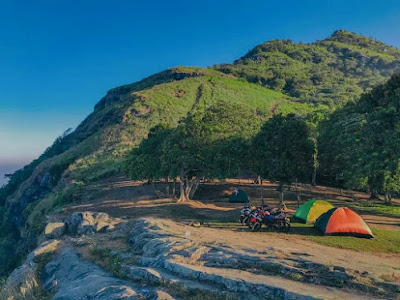
Peacock Hills is a nice  hiking  place in Sri Lanka. It is a  point with a panoramic view. The height of the Peacock Hills is 1518m above sea level.The mountain is situated in the Pussellawa area of the Nuwara Eliya District.Locals call this mountain “Monara Kanda” or "Monaragala" because it is shaped like a Peacock.


Monara Kanda also has a historical background. If we take the life story of King Dutugamunu , this village becomes a turning point because he spent 12 years in Kotagepitiya,a village at the foot of this mountain. Prince King Dutugemunu is one of the most famous kings in Sri Lankan history.Due to a conflict with his father,he fled to Kothmale and hid. It is also said that he lived in that village as a farmer and shepherd and he took his chicken to Monara Kanda.


You first need to come to Pussellawa town to start the journey.The distance to Pussellawa from Kandy is 35km and from Nuwara Eliya it is about 45km.It is a town on theborder of the districts of Kandy and Nuwara Eliya.After the pussellawa, you must travel another 5km to the starting point.You will see many beautiful tea plantations along that route. This is not a hard hike and you can come to the top within 30 minutes.From the hilltop, you can see Gampola Town, Nawalapitiya Town, Pussellawa Town, Nuwara Eliya Town, Ambuluwawa, Dolosbage Mountain Range,Piduruthalagala Range, Kothmale Reservior and Mahaweli River are some of the things that you can observe from the Monara Kanda.


 Kondagala


Kondagala is a popular hiking destination in Sri Lanka. Kondagala is located in the border of the districts of Kandy and Nuwara Eliya. It's a small mountain and very popular due to its surrounding beauty. The Loolkondera tea estate is another historical place that you should visit before the Kondagala Hike. Kondagala from Kandy city is about 32 km. This is about 20km from Rikillagaskada and 12km from Hewaheta town. If you are hoping to reach here from Colombo. You have to travel nearly 150km from there. 


Once you reach the top of the Kondagala, you will feel amazing. The top is frequently buffeted by strong winds. You can walk around there for a long time. 

Kondagala was very popular due to its large stones. If you go to the edge of the stones, you can see the beauty of the Loolkandura tea estate and the areas towards Galaha and Kandy. The summit of Kondagala Mountain is an absolutely beautiful place to take some amazing photographs. You can observe some old houses, paddy fields, tea estates, and other topographies in the Dumbara Valley. You can easily identify the famous Hanthana Mountain Range from here.


 Alagalla

Alagalla is one of the most popular hiking destinations in Sri Lanka . This mount range is situated in the boundaries of Kandy and Kegalle Districts.This can be observed during the Kandy– Colombo railway journey.After climbing this mountaion you will see a very beautiful viwe. The elevation of the Alagalla Mountain is 1140m above sea level.


There are many ways to reach Alagalla.,

If you begin your journey in Colombo or on the western side of the country, you can take the Colombo-Kandy train from there and get off at the Ihala Kotte railway station, which is the next station after the well-known Rambukkana Railway station.

If you wish to travel by bus or any vehicle you can take the Colombo-Kandy road and from Mawanella.Then you should take the Rambukkana road and from Gangoda. Then you can start your hike from there.

From Kandy If you start your journey in Kandy or the eastern part of the country, the Kandy-Poththapitiya route is the best option. You can hike to the Alagalla from there. However,it is a slightly longer route than the other options.According to your preference, you can also choose the Gangoda route if you can come to Mawanella.


Alagalla is situated at the edge of the central highland. This has made it have an amazing view point. You can see the larger area of four provinces in the country. Those provinces are Central, Western, Sabaragamuwa, and Wayamba.Also you can see other areas like Ambuluwawa, Nelligala, Hanthana Mountain Range, Bathalegala you can observe.

Hulangala

(Selagama Mini World's End)

Hulangala is located in Matale District, Sri Lanka.Selagama Mini World’s End is a beautiful destination in the border of Kurunegala and Matale districts.This a very beautiful place with a huge natural attraction and also a climate closer to Kandy.

Hulangala Punchi Lokantha is located at the southern end of theKnuckles Range in the Salagama Estate and can be reached from Kurunegala or Matale.From Kurunegala, travel towards Dambulla up to Thalgodapitiya Junction and turn to Yatawatta road.

The total distance is about 40km. To travel form Matale, you need to turn off at Palathwela to reach Yatawatta.From Yatawatta, take the road towards Selagama estate. At the estate entrance, you are charged Rs 250 for a vehicle.From the line houses of Selagama estate, you can hike for 2-3 km to reach the view point.However motor bikes, 3 wheelers and 4×4 vehicles can go right up to the view point.Little World is located at an altitude of 760 meters (2500 feet) above sea level. However, Mount Hulangala rises to 1,025 meters (3,360 ft).


Another experience you will get on this trip is the,You can also make a visit to the waterfall which also lies with the Selagama estate.That waterfall is called "Yatawatta Biso Falls".To reach the waterfall, you will need to turn right from the line of houses of the estate and go up to the Yatawatta Hindu Temple  and walk across some paddy fields to reach the top of the waterfall.


 Dolukanda

Dolukanda is a place of historical and archaeological importance, located in Sri Lanka.This is a mountain range famous for the Dolukanda Raja Maha Vihara.With the height of 600m. Dolukanda is one of the popular Ramayana places in Sri Lanka, this mountain is named as Dolukada Sanjeevani Kanda in the story of Ramayana. It is believed that parts of the Himalayas were felt by Hanuman when he was taken to Sri Lanka.


Dolukanda is located in the Kurunegala District of the North Western Province. About 15 km on the Ganewatta road from Kurunegala you can see Dolukanda in the far right.

There are two ways to access Dolukanda,

1.Kurunegala –> Muththettugoda junction –> Ganewatta –> 10th mile post –> Hunupola village –> Dolukanda

2.Kurunegala –> Ibbagamuwa –> Madagalla road –> Godagala –> Arankale –> Doluwa –> Dolukanda